Ocean Data Center
UCSC Project Data - Local Area Coverage (LAC) ocean color and sea surface temperature imagery at 1.1 km resolution from the SeaWiFS and AVHRR projects are posted within the indexed links below. All imagery are projected to cover the area affected by the eastern boundary California Current Upwelling System (CCUS). SeaWiFS data covering most of North America are available. For specific data requests, please contact the web administrator.
Satellite Oceanography Slideshows Year: 2001 2002 2003
CoOP WEST Satellite Data
NASA Projects Satellite Data
ECOHAB Project Data
DODS Archive Directories: satellite in situ
Individual images SeaWiFS: image maps individual (2000, 2001, 2002)
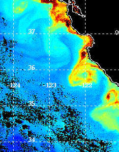
Individual AVHRR SST: Central Coast, CA 2000 2001 2002 Baja Peninsula, Mexico 2000
Mooring Data - In situ measurements taken from the Monterey Bay OASIS buoy network operated by MBARI, and the NOAA NDBC buoy systems. Data are organized by date, mooring number and instrument.
Additional data from Bio-optical instrumentation are available upon request and will be browsable online in the near future. This includes shipboard data collected during scientific cruises in the Monterey Bay and San Francisco Bay Areas. Measurements include multispectral backscattering, irradiance and radiance, spectral beam attneuation and absorption coefficients of the water, water temperature, salinity, and pressure. The instruments used to collect this data include: a HobiLabs HR-2 HydroRad multichannel hyperspectral radiometer, a profiling reflectance radiometer, and a multi-channel absorption/attenuation meter.
Ocean Sciences Department
All rights reserved.
Last Modified July 2000
Webmaster for this page:
< Patrick McEnaney (patrick@emerald.ucsc.edu)>
copyright 2000
Regents of the University of California